
F. W. Woolworth Co. Store
In the early evening hours on March 10, 1933, the Newport-Inglewood fault ruptured, jolting the local citizenry just as the evening meals were being prepared. The magnitude 6.4 earthquake caused extensive damage (roughly $50 million in 1933 dollars) throughout the City of Long Beach and surrounding communities. The City of Santa Ana suffered extensive damage, including the old Woolworth’s building on 4th Street, shown on the cover.
Preparing for Winter Storms
The City of Santa Ana Public Works Agency makes sandbags available to city residents and businesses during winter storms or rain events. Up to ten sandbags are available per residence or business location.
HAZMAT Response
The Orange County Fire Authority HazMat Team responds to investigate illegally dumped mercury, working in tandem with the Santa Ana Police Department as a joint hazard assessment team.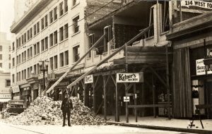
4th Street after the 1933 Earthquake
Buildings in Santa Ana experienced substantial structural damage from the 1933 Long Beach Earthquake. Shown here are storefronts along 4th Street, including the Spurgeon Building.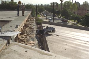
1994 Northridge Earthquake
The most recent serious earthquake in southern California took place in 1994, with an epicenter about 60 miles northwest of Santa Ana. Many roads, including bridges and elevated highways, were damaged by the 6.7 magnitude earthquake. The initial movement lasted more than 20 seconds and resulted in the death of 57 people, injuries to over 8,700 people, and over $20 billion in property damage.
Community Input
Residents expressed strong desires to maintain and enhance their quality of life through improved recreation, cultural, and educational programming during all phases of the General Plan preparation, including at events such as the 2018 Fiestas Patrias event (pictured above) and focused input such as the 2017 General Plan Advisory Group meetings.